BTLO Challenge: https://blueteamlabs.online/home/challenge/meta-b976cec9e2
Scenario
The attached images were posted by a criminal on the run, with the caption “I’m roaming free. You will never catch me”. We believe you can assist us in proving him wrong.
Tools Used
- ExifTool to analyze metadata of image files.
- OSINT to gather specific information through the internet.
Questions & Answers
Q-1. What is the camera model?
The basic security analysis usually starts from analyzing the metadata (Date, Accessed, File type, etc) of the evidence files. So, we shall check those 2 images metadata using a tool like exiftool:
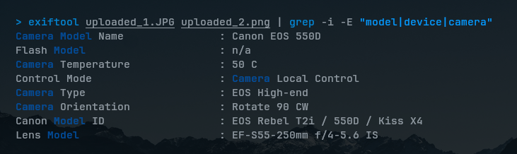
exiftool uploaded_1.JPG uploaded_2.pngThis will outputs so much metadata information, but we just need to focus on finding the specific metadata field related to Model, Device, Camera or anything relevant to camera model. That’s when grep comes in to help finding out the specific strings:
exiftool uploaded_1.JPG uploaded_2.png | grep -i -E "model|device"grep flags explanation:
-ifor case-insensitive matching.-Eto combine searching multiple patterns.
Now, we can see the camera model we’re looking for.
Q-2. When was the picture taken?
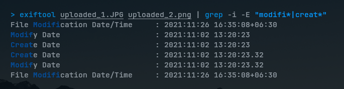
For this, we should focus on finding Created or Modified metadata fields when was the image files created. The metadata field names and the name in my mind might be slightly different (e.g., “Modified” could be “Modification Date” instead), so I combined the patterns just to focus on the word:
exiftool uploaded_1.JPG uploaded_2.png | grep -i -E "modifi*|creat*"And we found the information we’re looking for:
Q-3. What does the comment on the first image says?
To find the metadata related to comment on the first image, I did the same way to find the pattern:

Q-4. Where could the criminal be?
I tried searching for the GPS location in the metadata, which it seems exists:
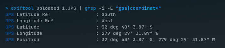
But when I try to search for its location on the web, the location doesn’t really exist. This could only be malformed as the comment said. However, the Google’s Image Search did the job instead of needing to decode GPS: